take a standardised approach

A Standardised Approach To Asset Management

By Map16, Mobile Collection, Solutions, Web Dashboard

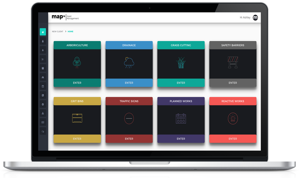
Our system provides 4 core aspects to make a standardised solution.

Why not standardise the way your organisation collects and manages all their assets, inspections and separate workstreams.

1 – Mobile Collection

map16 provides a mobile data solution for any business need. Map new features, collect new inspection records for all highway assets. Every aspect is streamlined to increase operational efficiency, and overall reducing the cost. Using innovative new technique to remove the need for work package creation and automation of asset revisit maps. Stay tuned over the next few weeks to read more detailed articles.

map16 - Mobile Solution


By creating a standard user interface, operatives working on drainage or safety barriers, will be familiar, and no extra training will be required.

2 – Inspection Dashboards

No matter what type of inspection data is required, we create a standardised approach to reporting. The focus of our inspection dashboard is to give clients the data they need at their fingertips. Export any data within two clicks.


Standardised inspection dashboards

A well crafted dashboard, should automatically reduce the work carried out behind the scenes in any business.

  • Overview of progress across the highway network
  • Clear KPI reports with exportable data
  • Crew reports showing progress and productivity
  • Defect reports or any other data available.
  • Road by road reports

All reports are designed for all data to be exported in any format required, including CSV, shapefile and geodatabase.

Find out More

3 – Asset Dashboards

In any good asset management system there is the ability to interrogate core asset data. Here at map16, we provide a standardised approach to asset data analysis from traffic signs to highway gullies. Customised to meet the need of every client.

Standardised asset dashboards

All reports are designed to be exported. No need to query datasets, everything has been created for you.


  • Overview of key asset figures (e.g. size, condition and number of species)
  • Breakdown of asset data based on geographic area. (e.g. district, parish, borough and ward)
  • Detailed breakdown of key attributes.(e.g. tree maturity, illumination type and cleanse frequency)
  • Defect reports or any other data available.
  • Road by road reports

Our bespoke dashboards create a standardised view for every asset.

4 – MapView

The final and maybe the most important aspect is the map view. This is the most used part of our system, as it integrates every aspect;

  • Current inspection data – Live from mobile collection devices
  • Historic inspection data – All data ever collected on the network
  • Asset data – No limit on asset numbers or types, point, polygon or polyline.
  • Road networks
  • Areas – Districts – Parish – Borough – Ward


Our standardised map views have the same tools through every system, asset or work stream.

Allows the workforce to seamlessly move between any dataset with no worry of additional training or getting lost in a complex user interface

Get In Touch And Lets Us Show You – 0800 772 396


map16 Asset Management ltd

One System Every Asset

By Map16, Mobile Collection, Web Dashboard

Have you ever wondered what it would be like to have all your highway assets in a modern, easy to use, standardised system? Look no further, map16 can provide exactly that.

Why not take a standardised approach to asset and inspection data across all highway datasets. Here at map16 we have provided that exact solution, crafted from years of industry knowledge and understanding of what current systems are capable of.

Why not standardise how your workforce view, monitor and export all highway data. Whether its drainage, grass cutting, grit bins or any other, we have a solution to meet your every requirement. Our light weight framework allows map16 to seamlessly design bespoke systems for all our clients.


map16 - Web Dashboard

Gully Maintenance

map16 - Planned And Reactive Works - Dashboard

Planned & Reactive Works

map16 - Arboriculture - Dashboard

Arboriculture

map16 - Grit Bin Maintenance - Dashboard

Grit Bin Maintenance

map16 - Grass Cutting - Dashboard

Grass Cutting

map16 - Traffic Signs - Dashboard

Traffic Signs


map16’s complete solution creates an industry standard of asset and inspection data collection, with custom fields and drop down options meeting all requirements. Work live or offline, without any work packages from the office. Not only are we trying to standardise how data is viewed across all work streams, but also change the way data is collected. See how map16 can save you time and money by working in a modern way. Check out our future posts to see how.

One system every asset. Create a standardised approach to mobile data collection and web dashboard reporting.

Get In Touch – 0800 772 396

map16 - Esri Partner

map16 Becomes An Esri Partner

By Map16

Organisations around the globe partner with Esri to help solve some of the world’s top geospatial problems by developing high-calibre solutions, services, content and hardware for the ArcGIS platform.

As part of the Esri Partner Network, we have access to a community of like-minded organisations, a world-class platform on which to develop your products and services, and most importantly, a solid partnership for sharing best practices and resources to ensure success.

Becoming an Esri partner, has given us the opportunity to expand our technology offerings, and enable us to do amazing work with geography and GIS.

Powered by the global leader in GIS solutions map16 can push forward to creating a standardised approach to asset mapping and inspections across the Uk highways.

Since we have joined, we have had access to a wide range of resources, opportunities and tools to help us plan and deliver our innovative solutions and services across the UK.

Find our partner page of the ESRI website


Welcome To map16

By Map16 No Comments

map16 has been an ongoing 5 year project to create a new way of collecting and inspecting large scale data, but also being simple and easy to operate for the end user.

Whilst we aimed to make it user friendly, it still had to capture the essence of a fully integrated asset management system.

With years of testing the market, from mobile GIS collection solutions to fully integrated enterprise asset management system, it gave map16 the knowledge to design a completely new system based around modern web GIS technology.


The obvious choice became apparent when we decided to embark on becoming an ESRI partner. Their mapping engine, allowed us to develop new ways of collecting large scale data, whilst providing the flexibility for changes to be made without huge development, saving time and more importantly cost for our clients.

map16 - Esri Partner LogoFind Out More


map16 uses Ordnance Survey data to provide accurate data collection solutions for every highway asset or work stream. These include gully maintenance, grit bin maintenance, arboriculture, grass cutting, traffic signs and all other works carried out on UK highways. Our key focus is to provide solutions that give our clients an innovative approach to risk-based maintenance regimes. Geospatial information can be used to create a targeted and a more cost-effective approach to highway maintenance.

OS is Britain’s mapping agency. As well as making the most up-to-date and accurate maps of the country, it is also a digital business. Together with its Partners it provides content helping governments, companies and individuals to be more effective both here and around the world.

map16 become Ordnance Survey Partner

Find Out More


Our ethos is to give our clients a new experience when using fully integrated mobile and web technology. We want people to use our system and not find it a chore day in day out. We pride ourselves with systems where data can be accessed within two clicks. This simple idea increases user engagement and allows every client to get exactly the data they require.

The idea of giving more and more users, access to the map16 system is one of our core goals. This is why whenever our mobile solution is being used, we provide unlimited web user access to every client. Even if its they have 2  to 2000 users.

map16 - Arboriculture - Dashboard


We provide industry standard mobile data collection solution for every highway asset, including drainage maintenance (All drainage assets), grit bin maintenance and management, arboriculture, grass cutting, traffic signs and safety barriers, just to name a few.

The map16 systems can be tailored to anyones needs and if we don’t have exactly what is required, we can build it for you for no extra cost.

Get in touch an see how we can provide your business with a solution to meet your needs.

Get In touch And Request A Demo
0800 772 396